4 incredible Rame Peninsula walks (near Plymouth)
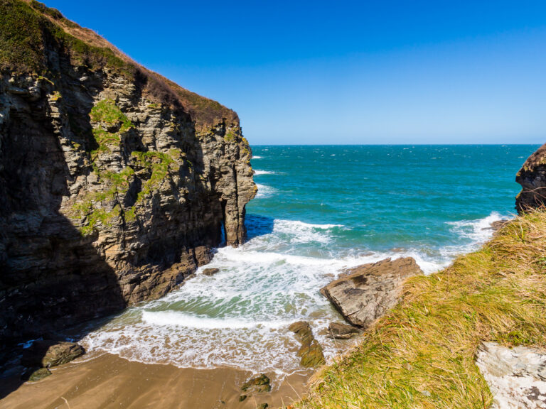
Rame Head was blustery. With the concrete remnants of a Second World War gun emplacement underfoot, I looked eastwards towards Devon as the wind whipped across the exposed headland.
To the west, I could see Cornwall’s cliffs stretching towards the horizon, but I soon stepped back from the edge to duck inside the slate chapel sat atop Rame Head.
Rame Head is one of the most distinctive landmarks on southwestern shores. The headland,
with its stone walled medieval chapel, has long served as a lookout point. For centuries, Rame
Head has guided ships and fishermen into the safety of Plymouth Sound, and even today, a
Coast Watch Lookout is set just a short walk back from the headland itself.
For hikers, Rame Head is a spectacular (if blustery) viewpoint situated on the Rame Peninsula.
The headland sits on the South West Coast Path, and a network of footpaths connect Rame
Head to nearby villages, including Cawsand, Kingsand and Cremyll.
If you’re planning a hike on the Rame Peninsula, here are the best ways to walk to Rame Head.
Where is Rame Head?

Rame Head is a prominent headland in the south eastern corner of Cornwall. Located on the
southern tip of the Rame Peninsula, it marks the western entrance to Plymouth Sound.
The summit is marked by a 14th-century chapel dedicated to St Michael, and the ruins of
coastal defence guns that once guarded the English Channel. From the top of the headland,
you’ll enjoy sweeping views of Plymouth Sound and south Devon. Look westward, and you’ll
see the Cornish coast extending towards Whitsand Bay, Looe and Fowey.
Part of the wider Mount Edgcumbe Country Park, Rame Head is only reachable on foot.
However, there is a small car park, a short walk across the muddy cliff top fields, and multiple
footpaths stretching across the Rame Peninsula.
Rame Head Walks
From short strolls to long hikes, here are the best walks to Rame Head:
From Rame Head Car Park

I’ll start with the shortest walk to Rame Head. From the small, gravel car park located on
Ramehead Lane, you’ll be just a 12 minute stroll from the headland. Park up, then walk through
the gate next to the Coast Watch Lookout.
You’ll find yourself in a field, often busy with cows, that stretches towards the clifftops. From
here, you can’t miss the slate chapel marking Rame Head, which rises rather dramatically
above the surrounding coastline.
It’s a short but fairly steep walk to the chapel itself, from where you’ll have sweeping views of
the English Channel. Head back down into the clifftop field from the headland, and you can then
link up with the South West Coast Path, or head straight back to the car park.
If you’re driving, this is the simplest approach to Rame Head. You can reach the car park via the
Torpoint Ferry from Plymouth, or take the longer route over the Tamar Bridge.
From Kingsand and Cawsand
Approx 3 miles each way.

The twin villages of Kingsand and Cawsand are one of the best jumping off points for a hike to
Rame Head. Located on the western shores of Plymouth Sound, the villages feature country
pubs, beachside bistros and plenty of accommodation options.
You’ll find plenty of parking in Cawsand but you can also leave the car behind in Plymouth
during the summer months. Between April and late October, the Cawsand Ferry connects the
twin villages directly to the Barbican Landing Stage, with regular crossings taking just half an
hour.
From Cawsand, the hike to Rame Head is around 3 miles, following the South West Coast Path.
First, head south on Earl’s Drive, hugging a lightly forested coastline until you emerge at Penlee
Point, where you’ll find the remains of gun batteries watching over the English Channel.
From Penlee Point, you’ll turn west, walking along the top of Rame Head Cliffs until you see the
chapel marking the headland. You can either return to Cawsand/Kingsand along the same
route, or cut inland for a 2-mile walk along country lanes to make this a circular route.
From Cremyll to Rame Head
Approx 9 miles each way.

For a much longer walk, I’d recommend tackling the coastal route from Cremyll to Rame Head.
The Cremyll Ferry runs all year round, connecting Cremyll Quay to Admiral’s Hard in
Stonehouse, Plymouth.
The journey takes just 8-minutes, and the ferry departs every half hour.
From Cremyll, you’ll simply link up with the South West Coast Path. The route first takes you to
Mount Edgcumbe Gardens. If you’ve got time, you can visit Mount Edgcumbe House, a grand
country home dating back to the 16th century.
If not, continue along the coast for an undulating 5-mile walk to Kingsand/Cawsand. The twin villages make for a great lunch stop (there are plenty of crab sandwiches to be had here!), before you continue south to Penlee Point, then west to Rame Head.
On the return leg, you can cut inland to Cawsand/Kingsand, follow footpaths uphill to Maker
Heights, then head along the ridge and down to Cremyll. The inland route is approximately 6
miles long, and saves retracing the same steps along the South West Coast Path.
From Whitsand Bay Fort to Rame Head
Approx 2.5 miles each way.
If you’re visiting Rame Head from the west, rather than from Plymouth, there’s a great walk from
Whitsand Bay. As the route follows the South West Coast Path, you can start anywhere
between Portwrinkle and Rame Head.
From Portwrinkle, it’s a longer 7 mile route (each way) to Rame Head. I’d recommend starting at
Whitsand Bay Fort, where you’ll find parking and cafes by an old Napoleonic-era fort that’s been
transformed into a cliffside resort. From here, it’s around 2.5 miles each way, following the
South West Coast Path along high cliffs, with salty-sprayed views of the English Channel.
You can extend the walk by continuing along the coast to Cawsand and Kingsand. From Cawsand, there’s an hourly bus service (70B) which can take you back to Whitsand Bay Fort (or all the way to Plymouth City Centre!).
See more walks around Plymouth here or check out other things to do in Plymouth here.